As insecurity continues to pose profound threats to national and regional stability in West Africa, innovative solutions are urgently needed to strengthen governance, enhance security operations, and build resilience.
One such strategic solution is using geospatial intelligence and enhanced Geospatial Data Infrastructure—an area gaining critical attention across the region.
In this feature article, Senator Iroegbu offers an insightful and timely analysis of the recently held ECOWAS Consultative Workshop on the Regional Geospatial Data Infrastructure (RGDI) in Lomé, Togo.
From his experience representing Nigeria at the gathering, Senator Iroegbu underscores how geospatial data integration can transform early warning systems, conflict monitoring, disaster response, and sustainable development efforts across West Africa.
His reflections highlight the pivotal role of geospatial intelligence and data infrastructure in addressing Nigeria’s and the region’s growing security challenges.
This piece is a crucial call to action for policymakers, security agencies, and development actors.
A Regional Call to Action
Data is the new power, and geospatial intelligence is key to unlocking West Africa’s security, development, and resilience. By harnessing it, we can predict crises, prevent conflict, and plan smarter. This was the focus of the recent workshop that laid the foundation for a Regional Geospatial Data Infrastructure (RGDI)—a significant step toward strengthening regional resilience.
In an era where insecurity threatens national and regional stability across West Africa, geospatial intelligence and data infrastructure have emerged as a transformative tool. The region, particularly Nigeria, faces complex and transboundary challenges, including armed banditry, terrorism, kidnapping, and environmental degradation. To counter these effectively, leaders and institutions are turning to geospatial data—an indispensable asset for evidence-based governance, conflict prevention, and sustainable development.
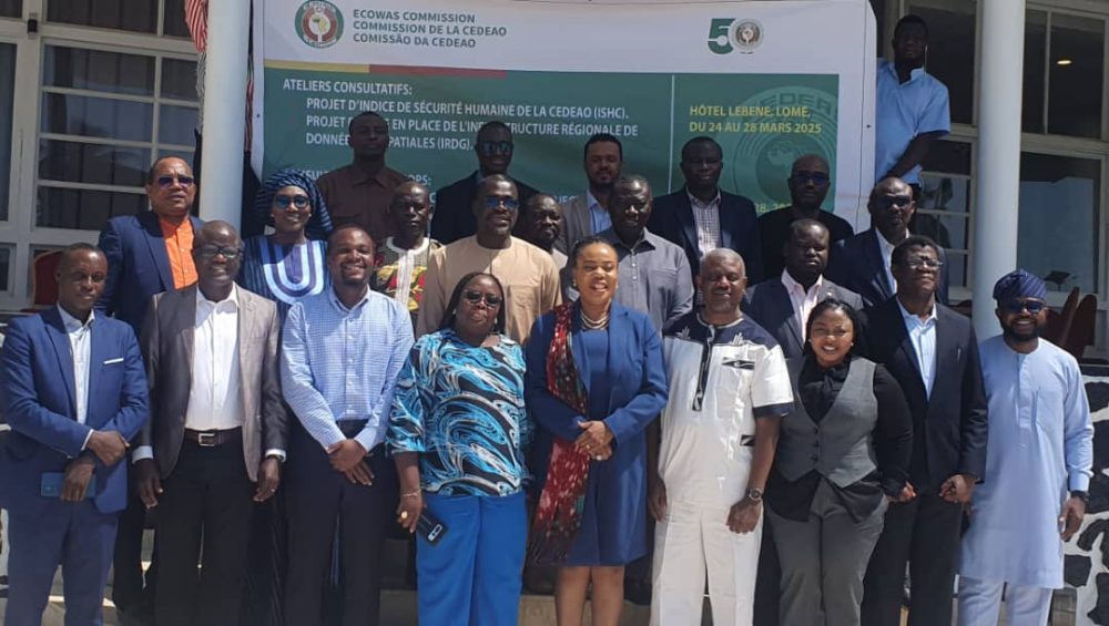
Recognising the urgent need for collective action, the Economic Community of West African States (ECOWAS) convened a two-day consultative workshop on March 27-28, 2025, in Lomé, Togo. The workshop aimed to establish an RGDI to support early warning systems, disaster preparedness, strategic planning, and security operations.
This strategic initiative brought together government officials, technical experts, academics, and development partners to validate a roadmap for harmonising and standardising geospatial data across West Africa. By harnessing the power of geospatial intelligence, ECOWAS aims to enhance regional stability, safeguard lives, and foster sustainable development.
I had the privilege of representing Nigeria at this strategic gathering, which emphasised the integration of geospatial intelligence into governance, disaster risk reduction, and regional security strategies.
The event featured key presentations, including the ECOWAS Human Security Index and an overview of the Early Warning System, highlighting the critical role of geospatial data in underpinning early warning and response mechanisms. Participants discussed sectoral data needs and data governance through thematic group work, focusing on security, disaster management, health, environment, and socioeconomic sectors. It also provided a platform for experience sharing, with representatives from Senegal, Nigeria, and Cabo Verde presenting their national Spatial Data Infrastructure (SDI) implementation journeys.
The workshop culminated in validating a common SDI framework, a crucial step towards strengthening early warning and resilience across the region. Participants brainstormed strategies for data collection, updating processes, and long-term sustainability, setting a strong foundation for operationalising an RGDI. This initiative promises to transform West Africa’s capacity for early warning, resilience, and sustainable development, fostering a spirit of collaboration, innovation, and shared purpose among participants.
It was agreed that as transnational threats grow more sophisticated and mobile, real-time geospatial data has become indispensable in identifying, preventing, and responding to crises that transcend borders. To this end, the collective mission was to validate a roadmap for harmonising and standardising geospatial data across ECOWAS Member States.
Strategic Imperative for Regional Security
The Vice President of the ECOWAS Commission, Mrs. Damtien L. Tchintchibidja, and the Acting Director of the Early Warning Directorate, Dr. Onyinye Onwuka, both emphasised that geospatial intelligence is not just a technical tool—it is a strategic enabler of governance, peacebuilding, and regional resilience.
Onwuka described geospatial data as “a cornerstone for effective security monitoring, environmental management, infrastructure planning, and strategic decision-making.” Yet, she noted, many ECOWAS Member States face challenges such as fragmented data landscapes, incompatible systems, and limited access to critical information, especially in moments of crisis.
“Data is often scattered, stored in incompatible formats, and inaccessible when most needed—for crisis response, strategic planning, or long-term development. This lack of coordination hampers our collective ability to make timely, informed, and efficient decisions that support our people and economies,” she said while declaring the event open.
To address these hurdles, ECOWAS is advancing the development of a sustainable SDI—a centralised, accessible platform housing key datasets such as administrative boundaries, land cover, infrastructure, schools, hospitals, and water assets.
“By improving data accessibility and interoperability, the SDI will enhance our understanding of existing infrastructure and natural resources. It will empower evidence-based development planning, optimise resource allocation, and improve national and regional decision-making,” Dr Onwuka explained.
She stressed that the RGDI initiative is not merely a technical aspiration but a peacebuilding and development imperative– a cornerstone of regional cooperation and resilience. “This is not just a validation workshop—it is about affirming our shared vision for regional geospatial integration and long-term infrastructure.”
Onwuka further noted that when linked with ECOWARN (the ECOWAS Early Warning and Response Network), geospatial intelligence and SDI can power more intelligent conflict monitoring, early warning signals, and timely, effective interventions. She urged participants to focus on sustainable implementation that is aligned with the national system. “This initiative will become a vital asset not only for ECOWAS but for every Member State,” she said, adding, “Leveraging geospatial data across all sectors is critical to driving informed policy-making, accelerating sustainable development, and enhancing our region’s resilience.”
Against this backdrop, Mr. Mouhammad Abdallah Diallo, the workshop facilitator and geospatial expert, reinforced the strategic value of the RGDI for conflict monitoring, crisis response, and human security. Diallo disclosed that six countries—Côte d’Ivoire, Gambia, Ghana, Guinea, Nigeria, and Senegal—have already participated in pilot assessments and consultations, laying the groundwork for regional implementation.
Nigeria’s leadership & committment
Nigeria played a prominent leadership role during the ECOWAS SDI Workshop, chairing Group 1 on Sectoral Data Collection & Updating Processes. At the forefront was Dr. Tubolayefa Warekuromor, Senior Special Assistant on the National Geospatial Data Infrastructure (NGDI) to the Director-General of NASRDA, and Senator Iroegbu, Convener of the Geopolitics Series.
In addition to chairing Group 1, Warekuromor also led the Anglophone Working Group, where she showcased Nigeria’s significant progress in NGDI development and efforts to align national initiatives with global standards such as UN-GGIM and the Integrated Geospatial Information Framework (IGIF).
“This workshop allowed us to share Nigeria’s experiences and learn from the regional community,” she noted, stressing the importance of political buy-in, sustained capacity-building, and establishing national geospatial clearinghouses to underpin evidence-based policymaking and security planning.
She commended the workshop for laying a strong foundation for deeper regional integration, particularly through linking geospatial infrastructure with the ECOWARN early warning system. “We made great strides in shaping the future of geospatial data infrastructure across West Africa, especially in integrating it with ECOWARN for enhanced regional security, food security, health, environmental, and climate change monitoring,” she said.
Highlighting the varying levels of NGDI maturity across Member States—from the more advanced systems in Nigeria, Senegal, and Cabo Verde to those just starting—Dr. Warekuromor found encouragement in the shared institutional structures and technical approaches: “It was beautiful to once again see the striking similarities in the institutional arrangements and technical approaches across the Member States.”
She emphasised key recommendations from the working sessions, including Aligning the RGDI with UN-IGIF and UN-GGIM Africa frameworks and establishing technical working groups based on UN-IGIF pathways and regional priorities. This also includes advocating for high-level political support to drive NGDI financing, capacity-building, and clearinghouse development.
In closing, the SDI expert expressed her gratitude for the platform’s contribution to shaping the region’s future: “I am grateful for the opportunity to contribute to advancing geospatial integration and digital transformation across West Africa.”
Unpacking the Geospatial landscage: Who manages what?
During the workshop, Nigeria chaired discussions on sectoral data management and updating processes, with representatives of Ghana, Cape Verde, Liberia, Sierra Leone, and The Gambia participating. The sessions revealed a common challenge across the region: although several national institutions manage geospatial data, coordination remains a significant bottleneck.
National Statistical Offices (NSOS) typically manage census and socio-economic data, Lands and Survey Departments handle geodetic and land parcel information, and Geological Survey Agencies produce mineral and soil maps. At the same time, National Mapping Agencies oversee infrastructure and boundary datasets. However, these agencies often operate in silos, with minimal data sharing and no unified geospatial strategy in place.
Only a few countries, such as Senegal and Cape Verde, have enacted legislation to establish national geospatial frameworks. Nigeria is working toward closing this gap by developing its National Geoinformation Policy and advancing the NGDI Bill.
Bridging the Geospatial Data Divide
West Africa’s Economic Community of West African States (ECOWAS) member countries face significant challenges in integrating geospatial data, hindering their ability to make informed decisions and respond effectively to regional challenges. Despite the importance of geospatial data in health, security, disaster management, and infrastructure development, the region struggles with fragmented data management.
The Challenges are Clear: For Nigeria, the lack of geospatial visibility across the North West and Middle Belt has made it harder to track armed groups, monitor population movements, and secure ungoverned spaces. This highlights the need for integrated, real-time geospatial data systems, which remain rare across the region. Ministries, security agencies, and infrastructure planners often work in isolation, creating silos that delay critical decision-making and collective action.
A Fragmented Landscape: The lack of integration is evident in various sectors. Environmental agencies lack unified platforms for disaster risk monitoring, while ministries of health struggle with disconnected disease surveillance systems. Infrastructure planning is also hindered by fragmented and outdated data on roads, housing, and utilities. This disjointed approach makes it difficult for countries to respond effectively to regional challenges and make data-driven decisions.
The Role of Technology: Data collection practices in West Africa blend traditional methods with modern technologies. Field surveys, national censuses, and aerial photography continue to play an important role, complemented by advanced tools such as drones, GPS, ArcGIS, QGIS, and GNSS systems. However, many countries still lack access to high-resolution satellite imagery and robust data storage infrastructure. Data repositories often remain uncoordinated, making timely updates and cross-sectoral integration difficult.
Practical Solutions: To tackle these challenges, workshop participants outlined several practical strategies:
-
Create a Common Language: Standardize geospatial terminology across agencies to enhance communication and reduce confusion.
-
Foster Inter-Agency Collaboration: Build cross-functional teams and establish regular data-sharing protocols to break institutional barriers.
-
Close Data Gaps: Invest in real-time data infrastructure and strengthen personnel capacity for data collection, analysis, and application.
-
Modernize Infrastructure: Upgrade GIS platforms to modern, interoperable systems that handle large, real-time datasets.
-
Enhance Security Capabilities: Use geospatial technologies to improve surveillance and situational awareness.
Building a Resilient Geospatial Ecosystem: To strengthen the regional geospatial data ecosystem, ECOWAS Member States and the Commission can take clear steps. Member States can centralize and audit data, modernize GIS systems, enact geospatial policies, enhance skills and collaboration, and secure sustainable financing. The ECOWAS Commission can conduct regional assessments, promote standardisation and data sharing, establish a regional platform, mobilise resources and political will, and coordinate technical working groups.
The ECOWAS Member States and the Commission can lay a strong foundation for a resilient, integrated geospatial ecosystem by refining and acting on these recommendations. This will enhance national security, drive development, and strengthen regional cooperation, ultimately powering faster, more thoughtful responses to the region’s complex challenges. With a unified approach to geospatial data, West Africa can unlock new opportunities for growth, resilience, and prosperity.
A Strategic Weapon Against Insecurity
The security threats facing West Africa today—ranging from terrorism, banditry, piracy, and illegal mining to climate-related disasters, food insecurity, and cross-border health emergencies—have outpaced traditional security responses. These complex, fast-evolving threats require smarter, faster, and more precise interventions. They demand innovative systems, predictive tools, and integrated data pipelines. This is where Geospatial Data Infrastructure (GDI) and Geospatial Intelligence (GEOINT) become strategic assets. GDI and GEOINT offer the ability to see more, plan better, and act faster.
Accordingly, the ECOWAS SDI Workshop in Lomé, Togo, reaffirmed that a resilient, integrated geospatial ecosystem is no longer optional but an operational necessity. This is because the Geospatial Intelligence Matters for Security:
Air Domain: Real-time tracking of aerial threats, unauthorised flights, and border violations through layered geospatial surveillance tools enhances Nigeria’s and West Africa’s airspace security.
Land Domain: Predictive mapping of conflict hotspots, illegal mining sites, forest incursions, and migration patterns enables smarter deployment of security forces and early warning mechanisms.
Sea Domain: Maritime Domain Awareness (MDA) is powered by geospatial data integration, enabling better tracking of pirate movements, illegal fishing activities, and maritime pollution threats across the Gulf of Guinea.
The GDI and GEOINT could apply in so many key areas, including:
Early Warning Systems (ECOWARN): Integration of geospatial datasets strengthens the predictive capacity of regional early warning platforms, enabling preventive diplomacy and preemptive security actions.
Surveillance and Reconnaissance:
Satellite imagery, UAV (drone) mapping, and ground-based GIS platforms are critical for monitoring insurgent movements, border infiltration, and environmental threats.
Disaster Risk Management: Spatial analysis helps predict floods, droughts, and disease outbreaks, allowing better coordination between security, health, and humanitarian agencies.
Counter-Terrorism Operations: Location intelligence, target profiling, and spatial behaviour analysis enhance tactical planning against terror cells and armed groups.
Urban and Rural Security Planning:
Urban GIS mapping supports city policing, emergency response, and infrastructure protection, while rural mapping aids in securing farmlands and remote communities.
The Way Forward
The Sectoral Data Infrastructure (SDI) Workshop was more than a technical gathering—it marked a strategic milestone for West Africa’s future security and development. Through the collective push to establish a Regional Geospatial Data Infrastructure (RGDI), ECOWAS Member States, including Nigeria, are laying the groundwork for a shared, standardised, and interoperable platform for geospatial data exchange.
The RGDI initiative promises to strengthen national and regional Geospatial Data Infrastructures (NGDIS), aligning them with international frameworks such as UN-GGIM: Africa and the UN-IGIF. It provides a robust institutional mechanism to support critical priorities like ECOWARN (the ECOWAS Early Warning and Response Network), climate resilience, food security, and maritime safety. More importantly, it offers a foundation for innovative, data-driven governance to anticipate, prepare for, and respond to security risks faster and more precisely.
For Nigeria, the stakes are even higher. Strengthening its NGDI and Geospatial Intelligence (GEOINT) capabilities is crucial for safeguarding territorial integrity across air, land, and sea, protecting vital economic assets, securing vulnerable communities, and building resilience against an increasingly complex threat environment.
In her closing remarks, ECOWAS Commission Vice President, Mrs. Tchintchibidja, commended participants for their active engagement and collective commitment. “The spirit of cooperation that guided this workshop has been inspiring and impactful,” she noted. “Your insights and recommendations have laid a strong foundation for institutionalising the SDI framework across the region.”
She emphasised that sustaining this momentum would require ongoing national commitment, deeper integration with ECOWAS structures, and more effective cross-sector coordination. “As you return to your countries and institutions, I urge you to carry forward the momentum and the shared vision that brought us together here in Lomé,” she encouraged.
Mrs Tchintchibidja reaffirmed the ECOWAS Commission’s unwavering dedication to building an interoperable, sustainable geospatial infrastructure that drives development, security, and resilience. “Together, we can build a robust, interoperable, and sustainable geospatial infrastructure that enables us to act faster, respond smarter, and plan better for the future,” she concluded.
Her remarks brought a fitting close to the high-level workshop, reinforcing ECOWAS’s commitment to geospatial collaboration as a vital instrument for early warning, effective planning, and sustainable development across West Africa.
Indeed, as Mrs. Tchintchibidja aptly captured it:
“Together, we can build a robust, interoperable, and sustainable geospatial infrastructure that enables us to act faster, respond smarter, and plan better for the future.”
The Lomé workshop was not just another meeting but a turning point. A clear consensus emerged: data is a new power. In today’s world, the strength, precision, and agility of West Africa’s response to emerging threats and opportunities will depend heavily on its geospatial intelligence capabilities.
In a nutshell, the RGDI, championed by the ECOWAS Commission, is far more than a policy framework—it is a strategic foundation for peace, security, development, and resilience in a region that needs all four.
Senator Iroegbu is the Convener of the Geopolitics Series and Editor-in-Chief of Global Sentinel. [email protected]